02/ Causes
Wildfires are primarily driven by climate change, development in the wildland urban interface, and an accumulation of fuel from prior fire suppression efforts.
01/ Stats
In 2020 alone, more than 57,000 wildfires burned 10.3 million acres of land across the United States, the largest acreage burned in a single year.
03/ Impact
First responders are faced with increasingly complex fire conditions, extreme weather, and intense fire seasons that are lasting longer each year.
Wildland fires are growing ever more frequent and severe, yet the tools to manage them remain the same.
Problem Space
We’re still fighting fire in the exact same way, [but] fire behavior and the magnitude of fire we are seeing today is not the same as what it may have been decades ago.”
Lindon Pronto
Senior Expert in Vegetation Fire Management, European Forest Institute
02 / Lack of Live Updates
Weather and fire behavior often change quickly, but this dynamic is not reflected in the current IAP due to its static paper medium.
01 / Labor Intensive
It requires several specialists working 16 hour shifts to manually collect and input data and print the night before for the next day.
03 / Safety Consequences
Decisions by the IMTs are made based on outdated information, leads to inefficient resource allocation, and compromises safety.
The IAP is labor intensive and lacks real-time information needed for Incident Management Teams (IMTs) to prioritize personal and operational safety.
Opportunity
E-IAP (Electronic Incident Action Plan) provides IMTs with real-time data to make informed decisions and support safety and accountability on the fireline.
Design Response
Research guided our team throughout the design cycle including literature reviews, competitive analysis, and semi-structured interviews.
Generative Research
How can we improve personnel and operation safety for wildland fire management teams by providing them with real-time data?

Literature & Policy Reviews
We conducted over 40 literature reviews that examined fire management organizations, policy rulebooks, and general wildland fire statistics and impacts.
This gave us a basic understanding of the organizational structure (e.g. Incident Command System or ICS) and standard policies that wildland fire management teams operate in.

Competitive Analysis
We evaluated eight existing technology products that were either marketed for emergency response use or consumer applications that fire responders used for a specific purpose.
This helped us identify limitations of existing products and assess the various types of features and interfaces being used.

Semi-Structured Interviews
We conducted a total of 24 semi-structured interviews that spanned the entire Incident Command System. They included firefighter trainers, policy makers, incident commanders, and experienced firefighters.
This gave us a cmprehensive understanding of the transfer of information up and down the chain of command and what information was deemed critical for each role during a complex fire incident.
Research Findings
01 / All emergency response operate under the Incident Command System (ICS).
The ICS is a standardized approach that specifies the hierarchy of authority and formal procedures for multiple organizations coordinating an effective emergency response. It consists of operations, planning, logistics, and finance/admin sections that can expand and collapse along with the size and complexity of an incident. This helped us navigate who to focus as our main stakeholders and who we needed to talk to.

We brainstormed >90 ideas to address how to use technology to improve the safety of wildland fire management.
Ideation
These ideas included map-based software systems, accessory items for existing tools, smart clothing items, tracking devices, warning systems, and even robots.

I co-facilitated a design workshop with two participants who voted on our ideas and wrote a story about how they could be used within the wildland fire context.
Design Workshop
The goal was to generate deeper discussions about a wide set of ideas, incorporate the perspective of our primary stakeholders, and foster a shared ownership of a vision for a future product. As a result, two ideas emerged.

1 / Optimizing Escape Routes
A map-based system that suggested optimal escape routes in an emergency fire situation.

2 / Digitizing the Incident Action Plan (IAP)
Transforming the static and outdated IAP into a dynamic digital one.
We conducted two field studies with the Northwest 12 Incident Management Team (NW 12 IMT) and dispatch center in Wenatchee, WA to gain first hand experience of the IAP life cycle.
Fire Field Trip
We met, observed, and shadowed different people within the ICS. We saw how resources were requested and approved, the technologies that they currently used, and took notes on what processes they wished could be improved.
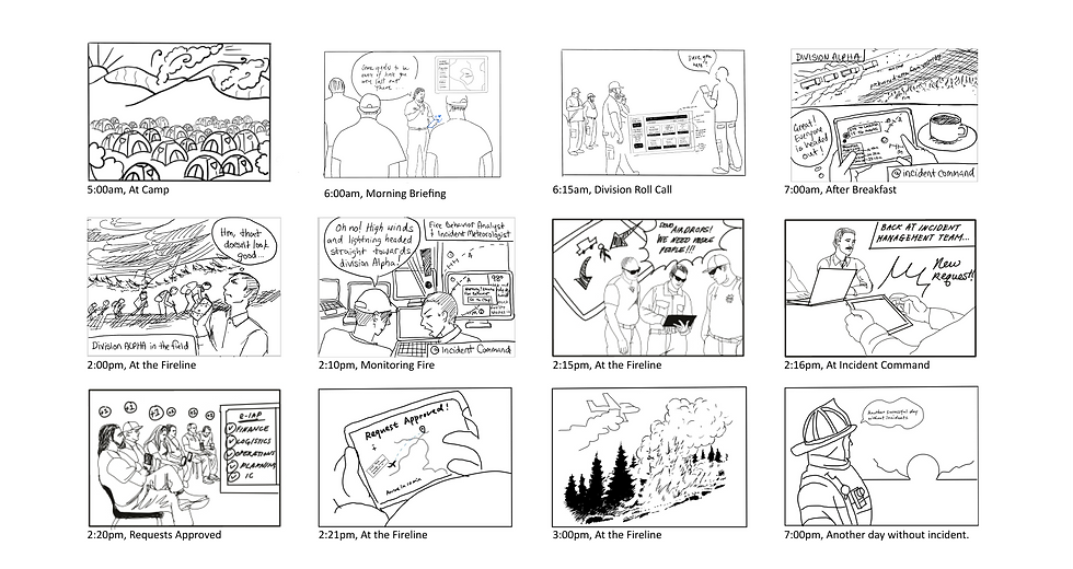
Using our research and experience in the field, we reimagined the IAP as the E-IAP at a wildland fire incident through a storyboard.
Storyboarding
This allowed us to combine our field experience, interviews, and past research findings to identify our stakeholders, the product form, and critical components of the IAP that were important for safety and accountability.
We used the structure of the paper IAP to organize the complex sets of information to optimize user navigation and encourage use.
Information Architecture
By following established structures and forms of the IAP, we can instill a sense of familiarity and trustworthiness from our stakeholders. In addition, we wanted to match existing mental models of where different types of information can be found. This would not only decrease the learning curve, but also encourage users to adopt this new platform in a new medium.
1. GIS-based interface
To allow IMTs to visually see assignments, weather, and fire behavior on the map in conjunction with textual information.
2. Personnel management
To keep IMTs accountable for the people assigned to the day’s operations by tracking their locations, work assignments, and statuses.
3. Resource management
To allow IMTs request, approve, and track resources that include both equipment and people with status updates, (e.g., resource ETA or person's last known location).
4. Real-time alerts and updates
Allow responders in the field to capture and submit photos to IMTs to collect real-time data for situational awareness. In addition, IMTs can send out urgent alerts to responders in the field.

I sketched an initial set of wireframes based on the core flows and information architecture that we established as a team.
Low Fidelity Wireframes
This was to map out the basics of the interface, its screens, and how the information architecture could be presented.
We tested key flows with two participants to refine our interactions.
Usability Study

Main Menu Navigation. The options included in the main navigation is always present unless the submenu is shown. We choose these specific items based on the frequency of use as validated by our participants during the usability study. Logged in users can view their assignments and qualifications and switch incidents.

Submenu. When users click on the menu icon from the main navigation screen, it takes them to the submenu that includes all the formal ICS forms and documents that are required by the government for record-keeping. We wanted to use existing documents to instill a sense of familiarity and match existing mental models.

Map Menu. On the map itself, there are filter options that allow users to toggle elements on and off to display specific information on the map. Each item is also labeled for reference. This was to allow users to filter for the information that they need and not overwhelm them with too much information all at once.

Map Zoom. Users can zoom in and out of the map to adjust different levels of information. The more zoomed in the map is, the more individualized, detailed, and specific information becomes visible. This is because different people from the IMTs need different level of information depending on their roles.
01 / GIS Map Functions
I led the design of the general map navigation that included both the main and map menus. This provided the foundation for navigating to all the other key flows. In addition, my team designed for different levels of details depending on how zoomed in the map was to account for different needs of the IMT.
2 / Personnel Management
Division Supervisors (leaders in the field) who implement operation strategies of the IAP for their assigned division on the field, uses the E-IAP to account for resources including personnel and equipment. This information is updated and can be updated throughout the day if any changes occur that can be accessed by other teams and groups in the same incident.
3 / Resource Management
Users can send, approve, and check the status of requests directly through the E-IAP. They can indicate where on the map the resource is needed. Depending on the type of request (e.g., new crews, dozers, airplanes, etc.), the form may change, but users can always allocate them directly on the map in relation to existing resources. These features allow users to check on resources when they need it to gain a better understanding of the situation or to reallocate resources for a more efficient incident response.
4 / Live Updates & Alerts
Responders on the field can send back real-time information to the IMT to help establish a more accurate picture of the situation on the field. In addition, I designed the alert system to allow responders and IMTs send out urgent alerts if a change in the field poses danger to people. This allows users to share information with people quickly without having to wait for the next in-person meeting or only being able to share the information they are directly in contact with.
There are multiple existing government platforms that are being used for wildland firefighting. In order to increase adoption and ease of use, we need to be able to integrate E-IAP with these existing platforms, (e.g., IROC, WildCAD, iSight, etc).
1 / Build in interoperability
Add the ability for teams to request and approve multiple resources at once. This would streamline the resource request and approval process especially for teams who are requesting different resources for one location. Additionally, if the E-IAP could stratisfy the different types of resource requests (e.g., urgency, approval requirement, frequency, etc), it would allow teams to prioritize the limited of resources on hand.
2 / Managing multiple, different resources
Explore different interaction types to assign personnel and resources. For example, instead of manually entering assignments, users can drag and drop a task to a nearby personnel.
3 / Prototype drag & drop interaction
Using other forms of feedback (e.g., haptic feedback) for alerts and requiring an action from users to verify they received the message to increase awareness and accountability. This is especially important because users may be bombarded with messages and notificaions that they become desensitized to another alert system.
4 / Provide additional feedback mechanisms
Conduct multiple usability studies aimed at studying the quality and accuracy control of information and interactions on a digital platform. Since failures in technology in wildland fire can be a life or death situation, we need to ensure that the interactions are designed in a way that allows for precision and limit mistakes.
5 / Validate to ensure interaction accuracy
If this project was to be continued, these are the next steps I would take to strengthen and validate the E-IAP.
Next Steps
We can see the safety benefits that this product can bring to a wildland fire management as well as streamlining our planning process, creating efficiency, and reducing costs for wildland fire because of the planning process being in real time…I would hope that somebody in the industry would take this project and this idea and run with it. There is a great need for it, and it would bring us into modern times here in so many ways.
Bobby Sinclair
Incident Commander, NW 12 IMT
I’m very impressed with how many of the items that we brought up as ideas...things that I only mentioned once and they incorporated nearly all the things. [The team was] very engaged and I think they have the ability to turn a great product.
Howard Johnson
Planning Section Chief, NW 12 IMT
This is fantastic and I do believe it’s probably the wave of the future…Imagine an injury and you have a REM, a Rapid Extraction Module with a paramedic. The individual’s location could be easily marked on the map and where the REM is. We all know about what we call the "golden hour," getting help there to critical injuries with under an hour to definitive care, so this could be this could be a big step forward on that part.
Richy Harrod
Retired Incident Commander
E-IAP concept has now sparked conversations in industry and government.
Our advisers from Launch Consulting shared our work with their government sales team to figure out how they can mobilize our research and proof of concept into a reality. They are currently having conversations with government contacts and fire captains in California to arrange a communication package for Governor Newsome and other potential buyers.
This interest validates that this problem space is a real pain-point and that there is a future for this type of platform to exist.
This project was exciting, challenging, and tiring all at once because of its complexity. However, I've learned so much in such a short period of time.
Reflection
01 / Experiences are irreplaceable
Field research put ideas and concepts into context and challenged my assumptions of what fire responders did. I gained a greater understanding about the field of wildland firefighting and how each of the different roles of the ICS operated to create an IAP.
2 / Don't stop at limitations
Despite limitations and hesitations about using technology in the fire field, design can be used to excite personnel by offering them ideas about what a realistic future could be.
3/ Focus on one thing
It’s easy to get overwhelmed and distracted with all the potential problem areas in a complex space, but trying to solve for everything is messy and unrealistic. Set realistic expectations, narrow in on one idea, and focus on executing it well.


02 / Tablet and mobile interface
We also imagined the product to be tablet and mobile based because these were the technologies we observed being used.
01 / IMTs as primary stakeholders
We imagined our primary stakeholders to be members of Incident Management Teams (IMTs) who make decisions about logistics and tactical operations and people who implement these decisions.

Once the key flows were identified, I iterated on a floating left menu navigation to maximize the map interface for easy navigation.
High Fidelity Wireframes
A usable and simple navigation was the first step to allow users easily access and identify the core features of the E-IAP especially due to the complexity and amount of information in this space. We wanted to make it as minimalist and non-intrusive as possible so that users were not overwhelmed with too much information.

One of these tools is known as the Incident Action Plan or IAP.
The IAP is a paper document that guides the overall response strategy to accomplish incident objectives. It is created by the Incident Management Team (IMT) who are tasked to command, control, and coordinate emergency responses. It is used to communicate and disseminate critical information, including incident objectives, assigned resources, fire and weather forecasts, and other related information.

02 / Safety is the top priority in wildland fire management.
One of the major challenges IMTs are facing is the inability to track personnel and resources due to communication issues. As a result, IMTs don't know where their teams are or the resources they have assigned, often operating on incomplete information.
This means our product design must aid communication of critical information and not impede or congest it. Additionally, it must build in redundancy features that prioritize safety and accountability of people and resources.

03 / Fire situations are dynamic and can change rapidly, demanding real-time data.
Factors like weather, fire behavior, and humidity can quickly change the course of a wildfire. But, the information does not always keep up and responders end up working with outdated data.
This means our product must be adaptable to the changing circumstances to gain an accurate representation of the situation, known as “situational awareness.” The key to accomplishing this is to provide real-time data.

04 / Technology is a key enabler in delivering real-time data.
Technology is being used more frequently despite the resistance to change in the fire community and connectivity limitations in remote areas.
This means our product will leverage existing technology to minimize cost and learning and modernize how fire teams access critical information.

1 / Excitement from participants
Two out of the three participants were captivated by the idea a digital IAP and came up with multiple features that they wanted to include, such as the ability to see graphical representation of resources on the map, updated real-time data, and weather information.
2 / A flexible and adaptable tool
All participants saw the potential for the digital IAP to be adaptable and flexible, in contrast with the current paper process. This would eliminate the dependency on paper and allow real-time data to influence decision-making.
3 / Potential for immediate impact
The digital IAP would also streamline existing processes such as tracking personnel, equipment, and allocating limited resources more efficiently. The easy access and transparency of this knowledge would increase responders' situational awareness, which would ultimately improve safety.
Why the E-IAP?
03 / Core IAP compoents
Why the floating vertical navigation?
-
Horizontal navigations were harder to reach on a tablet and were better suited for desktop use.
-
Minimal navigations maximized map screen real estate, which is the primary display of information.
-
Menus needed to be clearly labeled because of the specific needs of wildland fire management.

Weather & Behavior Feedback
Weather and fire behavior information should be visually displayed on the map so weather specialists and analysts can track changes and patterns.
Map Feedback
Need more map interactions that allowed users to edit and interact with the map itself. This will provide more visual information that users can receive with a glance.
Features Feedback
Refine which features needed to be always present on the interface versus ones that should be shown on the map after a particular action was taken
Our Response
Additional weather and fire behavior map layers were added. For example, adding a map that showed the wind direction or showing a heat map that displayed different temperatures.
Our Response
A interaction wheel was added to allow users to directly perform key actions on the map. For example, adding photos, viewing assignments, and navigating to a point.
Our Response
Adding the option for users to toggle on and off certain map options. Users can view more information when an item on the map is tapped. Lastly, adding a multi-level zoom for different levels of details.


Roll Call. Division supervisors can check their assigned personnel as "present" or "absent," to account for their people before heading out to their assignments.

Navigate to Assignment. After roll call, Division Supervisors can easily navigate to their assigned area without getting lost.

Resource Request. Users can send requests using the integrated ICS-213 Resource Request Form. For example, users can request an airtanker, specify the drop point, and any additional details regarding the resource to be sent for approval.

Resource Approval. Once the resource is submitted, it is sent for approval by the IMT. The team reviews the details of the request and can either approve it or send it to dispatch for further action with the dispatch WildCAD system.

Resource Status. Each resource can be located on the map. When the resource is tapped, a panel pops up where users can find more information about the resource. For example, if the resource is personnel, users can tap to view their division assignment, their assigned shift and task, their last known location, and etc.

Resource Tracking. Users can also track a resource that has been requested and approved. For example, users can track the airtanker's estimated arrival time so teams know exactly when they're receiving their resource and prepare for its arrival.

Image Capture. Users who are on the field can either tap a resource on the map or click on “edit map” to add an image with a description to send to a specific person on the IMT. For example, if a user wanted to capture a photo depicting the current weather, they can send it to the incident meteorologists and fire behavior analyst for approval. Once approved, the photo can be distributed to the entire team.

Alerts. Users can send an urgent alert to notify other people and spread the information. Changes often include wind direction and speed, lightning potential, aggressive fire behavior, or injuries. The E-IAP prompts users to confirm that they have received the alert, giving feedback as to who specifically saw the message.


Role
-
UX/UI design
-
Design workshop
-
Prototyping
-
Storyboarding
-
Interviews
-
Field research
-
Usability testing
Tools
-
Figma
-
Miro
-
Google Sheets
Team
-
Ran An
-
Joan Williams
-
Fontane Wong
Timeline
-
6 months
-
Jan - Aug 2021
This project was advised by Launch Consulting and consulted by the Northwest 12 Incident Management Team. It was a culminating capstone project that involved three months of dedicated research and another three months of design.
Project Overview
Designing for wildland fire management.


E-IAP (Electronic Incident Action Plan)
A GIS-based platform that provides Wildland Fire Incident Management Teams (IMTs) with real time information and situational awareness to support informed decisions for responder and operation safety.
Every part of this process helped us refine our E-IAP design and how it functions during a typical wildland fire incident for IMTs.
Product Walkthrough
The following are key flows that highlight how E-IAP transforms the way current fire teams develop and communicate tactical and logistical information about daily operations.